Posts & Media

Funding public projects in chaotic times

This post also appears at Future of London (my sometime other hat). You can find links to key FoL research below.

This post updates some of the findings in FoL’s Paying for Public Projects briefing, the product of three late-2019 roundtables and further research by 2016-20 Head of Knowledge Amanda Robinson. The programme was supported by Montagu Evans, Poly Group and Lewis Silkin.

Get ready to flex. Over the last 10 years, housing, infrastructure and regeneration delivery has been moulded by austerity and political flux; all sectors responded as well as they could. In the last three years, add the tragedy and deep impacts of Grenfell; climate declarations & court decisions; Brexit (remember that?); and now Covid-19, with its awful death toll, its policy and fiscal upheaval, and its economic ravages.

London’s incandescent glow was also starting to fade a bit before the pandemic, with medium-term value growth in the housing market forecast well below other regions and a cooler reception from central government as part of regional ‘levelling up’. That may seem fair in a national context, but it doesn’t help get projects funded.

Through it all, public project leads from all sectors have had to secure finance for upfront costs and funding for operations and maintenance. Budget cuts and housing policy were already pushing the public sector to risk more via joint ventures and council building programmes. Housing associations – partly in response to grant cuts and rent caps – reviewed activity, assets and tenure, embraced shared ownership; merged and morphed; and ventured into modular construction.

For councils in particular, finance has been a rollercoaster: removing the cap on Housing Revenue Account borrowing freed their aspirations; a year later, the 1% hike in Public Works Loan Board interest rates – partly in shock (…) at borrowing levels – slapped the curb back on and sent projects across the country reeling.

We will also lose EU funding – the Structural & Investment Fund alone is worth £5.3bn to England – but the replacement UK Shared Prosperity Fund is not yet defined and could be eroded by the flood of Covid-19 emergency spending.

To assemble finance and funding packages (and critical support), organisations of all kinds have been partnering more – from multinational masterplan partnerships to regional and local projects relying as much on social as on financial capital.

The fitness of other options, including municipal bonds, institutional investment and bank loans, will become clearer over the coming 6-12 months as the UK emerges from lockdown and assesses the economic damage.

Unfortunately, there’s a constant through all of this: a shortage of skills, capacity and understanding.

Whatever the tools, public project leads – especially at councils – can lack expertise, experience or just the time and headcount for effective funding and finance. Across the table, many investor and development partners still don’t understand the political or process realities of public delivery. Housing associations have been able to hire – though watch for the pandemic’s budget impact – but are increasingly challenged on ‘mission’. Having cash doesn’t mean the pressure is off.

Paying for Public Projects report

Early in 2020, Future of London combined its own research on the above with insight gained from three senior roundtables to produce a briefing on trends, risks and opportunities: Paying for Public Projects.

Supported by partners Montagu Evans, Poly Group and Lewis Silkin, the programme was designed to build public sector knowledge of funding sources and to help delivery teams and funders appreciate each other’s drivers and constraints. Covid fallout may shift the dial on best-fit funding, but the principles hold true.

The report provides cases and resources on trends including:

  • Investment shifting from inner to outer London. From 2015/16 to 2018/19, housing starts in inner London dropped by 57% while outer London marginally increased[1].
  • Investors attracted to assets offering revenue-generating potential and longer-term capital gains[2].
  • Climate issues affecting investor attitudes. Some are divesting from fossil fuels and applying ‘temperature scores’ to grade their portfolios[3]. Others heard the Court of Appeal decision against Heathrow expansion with trepidation. It’s under appeal, but it was a marker.

“Montagu Evans was delighted to support this programme,” writes partner Oliver Maury. “In the context of Covid-19 and its impact on society, our ability to share knowledge and experiences, in this case in relation to the funding of public projects, is more important than ever. As society turns its attention towards the recovery phase, we see organisations like ourselves and Future of London having an important part to play.”

So how can public project leads respond now?

There are still opportunities for public project funding – some perhaps growing as priorities shift…

  • A stronger emphasis on placemaking has been creating more resilient neighbourhoods that build on local identity and respond to local need. This strategic approach to regeneration demonstrates public sector leadership, which in turn inspires investor confidence. What happens now, as battered small businesses struggle to recover or leave shops vacant, is critical – council and landlord actions and attitudes are key to sustainability in every sense.
  • Emphasising – and clearly defining! – social & environmental value are likely to become more of a factor, as are explicit community support and mandates such as estate regeneration ballots. Because of their responsibility to communities, public-sector organisations are more likely to call for projects that maximise these values – and attract the growing number of investors with similar ambitions (viz the rise of Environmental, Social & Governance or ESG investing).
  • Good asset management is linked to both of the above. Rather than selling off, local authorities and housing associations are using mechanisms like income strips[4] to retain control of assets and explore income-generating opportunities as landlords. Again, they need the skills to do this well and the resources to scan the horizon for risks and opportunities post-Covid.
  • In London, engage with the Mayor’s Good Growth theme, with funds and support for projects offering the above and/or citizen engagement and diversified local economies.
  • Look to outer boroughs: There was already a huge amount to do in Outer London ­– and outside the centres of most UK city-regions – as town centres and high streets struggled to evolve. There will be ten times more to do now that they risk being hollowed out – and there will be public and private money ready to invest. What is brought back or built will be critical.
  • “Be shovel-ready”: This from a Leaders Plus candidate in Greater Manchester, but applicable anywhere. The UK will emerge and central government – from Homes England to the Department for Transport – will spend to help rebuild the economy. Moving ahead with deals, design, planning, consultation and procurement will help capable entities stand out when those initiatives kick in.

How do we look further ahead?

Scan. Listen. Learn. Collaborate. Flex.

Stability is never permanent, and the funding landscape will continue to shift. A key takeaway from the last 10 years was that local authorities must be more resilient when it comes to economic shocks. A key takeaway from the last two months is that central government will spend in a crisis. It remains to be seen whether that means a revolution in fiscal policy – with a return to serious housing and care funding, for example – or it means the cost of repayment will drive councils further into the red. What can we do to prepare?

Scan: Public project leads need to understand what funding sources are available, which are emerging, which are safe, and who’s using what. Carve out time for your team to scan good publications – or commission summaries if you have the budget. Room 151 is good.

Listen: Talk with colleagues beyond your organisation, via Future of London, professional groups and live or online networking events. Mentoring and board service across sectors or disciplines are great ways to do this.

Learn: Take courses, read the FT, Economist or HBR, listen to brain-stretching podcasts. Look at successes and failures and go beyond the gossip to what actually happened. Take your CFO for a coffee and ask how things work!

Collaborate: Work with each other. Share knowledge. Share people via secondments. Try using consortia once in a while to keep things fresh. Do a project or have a meeting with a competitor.

Flex: Doing the above, using tools like Future of London’s report and wider network – and having trusted outside help where warranted – can give public sector officers the confidence to take on risk and make fresh decisions. At the same time, those practices can help savvy private-sector operators understand partners and clients better, and by extension help repair public trust in the development and regeneration process.

FoL’s Paying for Public Projects programme brought together cross-sector development, housing, regeneration and funding partners to help build mutual understanding. In 2020, FoL is set to launch a new training programme for public project managers. These courses will be designed to help practitioners enhance their commercial skills by learning about viability, asset management, contracts and negotiation. Find out more here, or contact FoL Chief Executive Nicola Mathers at nicola@futureoflondon.org.uk.

Download the full Paying for Public Projects report here.

Get involved with Future of London’s useful work and excellent 4,600-strong network here.


Footnotes

  1. MHCLG Table 253: permanent dwellings started and completed, by tenure and district. Inner/outer London definitions follow those used in the London Plan. Some figures imputed by MHCLG in the data table. bit.ly/32d7gyj
  2. Hugo James. “The rise of long income property as an asset class,” 15 Jan 2020. www.investmenteurope.net/opinion/4009153/rise-long-income-property-asset-class
  3. Simon Jessop, Matthew Green; Reuters. “Climate change pushes investors to take their temperature,” 20 Jan 2010. reut.rs/2V9PFFU
  4. Clive Pearce. “Freeths Real Estate Law Blog: Income Strip Leases,” 5 Sep 2019. www.freeths.co.uk/2019/09/05/income-strip-leases/


Mapping our future

This is a guest post from Rebecca Lee, Senior Architect at Pollard Thomas Edwards and Future of London ‘Leaders Plus’ alumna. She and Coherent Cities director Lisa Taylor organised the Dec 2019 #MapLondon conference based on Rebecca’s FoL Proposal for London – and her growing obsession with digital mapping…

In 2017, as part of FoL’s Leaders Plus course, I presented a proposal to improve London by creating a comprehensive, citywide map to help us understand the many layers of contemporary city life. I wanted to digitise mapping, inputting historic and current data to learn about the past, understand the present and see where we might be going in the future. I knew it was a good idea when I realised that many people, across several disciplines, were already pursuing it!

Since the FoL course, I’ve become a champion and a nuisance for map creators, eager to get experts of all kinds talking so they hurry up and build the tools I want to use, both in my work as an architect and as a city-dweller.

The culmination of this was the December 2019 #MapLondon conference, organised by me and Coherent Cities, supported by Future of London, Pollard Thomas Edwards and Commonplace, and hosted by Arup.

Cartography is a long-standing form of data visualisation and #MapLondon will explore how new tools and techniques are being used to engage and inform built environment professionals and the public. What follows are a few of the issues that have driven me as this event and network come to life…

Should we map change better (again)?

Mapping has historically been a priority following disaster or cataclysmic change. The map below shows the impact of the 1666 Great Fire of London, when narrow streets packed with badly constructed wooden buildings led to 373 acres of the city and 13,000 homes being consumed (Source: British Library)

Similarly, many maps documented the devastation WWII wrought on London. The bird’s-eye view below shows how close St Paul’s Cathedral came to destruction. My favourite fact about this map is that no one is sure how the detail was achieved. It’s been suggested that architect and artist Cecil Brown sketched from a hot air balloon, but there is no proof of this. (Source: London Topographical Society, Pub. No 142, 1990. Photo: Rebecca Lee).

Abercrombie’s 1944 London Plan used creative cartography to respond strategically to the problems London faced during and after the war. It helped structure the approach to rebuilding, but also addressed poverty, overcrowding, poor housing quality and traffic congestion. Having recently surpassed London’s pre-war population, we now face many of the same challenges (Source: BarbicanLiving).

How can digital mapping make cities and regions more coherent?

Back in the present day, the digital maps that 26 of the 32 local authorities have been developing can be incredibly useful for understanding a site in context, or “beyond the red line” as we say at Pollard Thomas Edwards. However, what happens along the many kilometres of edges where boroughs – and their policies – meet?

Further, many of these borough-commissioned or off-the-shelf maps use different levels of information, graphics and interfaces. A consistent strategy is required to stitch these edges together and provide a coherent approach to development across the city. For more on this, see FoL’s work on Overcoming Barriers.

The Greater London Authority is central to this effort, driving cross-borough collaboration and providing valuable data and tools such as the London Datastore, London Infrastructure Map and Cultural Infrastructure Map. The recent requirement for planning applications to be logged via the planning portal informs these maps, to ensure that data is reliable and up to date.

The more I’ve spoken with people developing digital mapping tools, the more I’ve heard that my original proposal for “one map to rule them all” was a terrible one. Who would input the data? How could we make sure it was up to date? How could we avoid misrepresentation? Who/what is included or excluded? Essentially, how could we trust it?

No matter the format or scope, what is critical is that maps, data and the people who work with them speak to each other, so we can plug in different data sets and begin to see where societal needs correlate. #MapLondon connects end-users with those gathering the data and building the tools, providing a platform to expand collaboration across sectors.

Can maps support democracy?

Maps have always been tools of power and propaganda (among other, more benevolent uses). What makes recent advances in open-source data and GIS so exciting is the democratisation they allow. We are moving toward a place where everyone – as professionals or citizens – has access to tools to understand and help define place. ‘Empowerment’ is one of the conference workshops; appropriately enough, the topic was crowdsourced via the Urbanistas network for women in the built environment.

Do maps need to be beautiful?

A critical thing for me is visualisation of data, the wonderful combination of art and science. That maps are digital shouldn’t mean any less attention is paid to the aesthetics of the representation; a map must have a beautiful clarity in order to best communicate information to the user.

This is exemplified in the book Information Capital, by James Cheshire & Oliver Uberti (Penguin 2016). What makes these maps so interesting is the connection between place and people; we can all recognise the shared experience of living in a city, but there is beauty in seeing it from a new perspective.

The visual nature of mapping also drove us to host a poster competition. You can see the excellent finalists here and they were also on display at the conference; attendees received an A3 copy of the winning poster by colleague Peter Watkins (I’d stress that the judges were all independent!).

Can maps bring us together? (Yes!)

In closing, I found it surprising that those who could benefit most from these tools often seem unaware of their existence, but it’s understandable: the speed with which platforms and apps appear is near-impossible to track; experts can operate in silos; and end-users are often too busy to look up or too frustrated to ask questions.

#MapLondon tackled these disconnects by bringing people together across the industry. One of our goals is not just to do better here, but to make London the prototype for collaborative digital mapping, and to lead the way in the UK and internationally. Enabling a global mapping dialogue is a distinct possibility; a proposal for the world, maybe?

To see conference speakers & presentations, visit the #MapLondon page; to find out more, email info@coherentcities.com.

Notes from a small, weird town

Just visited my old stomping grounds in Moab, Utah, pop. 5,200. A uranium town, adventure sport hub and now second-home magnet, this joyous mash-up of rednecks, hippies and everyone in between has boomed and busted repeatedly. It’s now at risk of becoming a municipal cautionary tale.

One of the better ones – but no sidewalk!

After years of gradual change, 2014-17 saw monstrous growth, and I use the adjective advisedly. The newest half of the 20-odd motels lining Main Street ignore local character and have no provision for staff accommodation, in a region where a cleaner’s one-way commute can be above 180km. The explosion of road-legal 4x4s called Razrs has meant this formerly seasonal town is now rammed 9-10 months of the year and rental homes are sprouting like mushrooms. Rooms are renting for US$600-800 each and the median home price is US$355,000. Median household income is US$41,500, but the bulk of jobs are at or below minimum wage.

The construction mini-boom is all by the book, which is part of the problem. With one trained planner and a five-person planning commission v. an ardent and noisy pro-development lobby, city planning can barely keep up with applications and enforcement, and has no scope for strategy or policy review. (Their third agenda item for 22nd Feb is “Updated list of barriers to affordable housing”.)

Like all American municipalities, Moab operates on zoning (Wiki primer here) – the system has lots of fans because of its simplicity, but in resource-strapped towns like this one, zoning can be seriously out of date and no longer fit for purpose. And while zoning allows for variances, there is no scheme-by-scheme negotiation as in the UK, and there is usually no affordable housing requirement for new development. In a town where the bulk of employment is low-paid tourism work, that is massively counter-productive.

This is also high desert, where precipitation is tracked religiously and running out of water is not an idle threat (viz Cape Town, SA). Moab caps an 18-mile-long valley, the southern half of which is in an adjacent county not known for planning or environmental restraint. San Juan County wants another 5,000 homes at that end of the valley – doubling the area population. While the county promises a new reservoir and infrastructure provision, any water or sewer failure is likely to be blamed on Moab, which will be the new subdivision’s services hub.

There is also a lot to be admired here (aside from the national and state parks, wilderness trails and snow-capped mountains at its doorstep). Moab City is home to the Best Small Library in America (2007), lovely bike paths, new schools and sports facilities, geothermal heating for municipal buildings, strong community and recycling support and a disproportionately large Pride festival; it has not forgotten locals in the scramble for tourist dollars.

Much of the town’s success is due to leadership: it had a hugely progressive city manager for 21 years, and its new and equally forward-thinking manager,  formerly Chief of Staff for Salt Lake City, is focused on strategy over catch-up. The City also seems to be getting along better with the surrounding and much more traditional Grand County, but time will tell.

Moab’s resilience is also due to the entrepreneurial and sometimes anarchic attitude locals and ‘seasonals’ – especially boating, biking and climbing guides – have about helping each other. Events like the Trashion Show raise funds for recycling, and landowners house needy kindred spirits in anything they can lay their hands on. Moab Valley now feels like a cross between (old-school) Burning Man and Pleasantville – not home to me any more, but still working for a lot of people.

Does this microcosm of tourism and development have any lessons for London and/or other places in the UK? Aside from the above about leadership and the long view, we could learn from them and pursue a tourism or transient room tax of some kind to mitigate the burden visitors place on infrastructure (and our patience!). We can also take heart that for all its shortcomings, we are actively working on the relationship between jobs and housing, on improving the environment, and on allowing room for the kind of entrepreneurial spirit that thrives in these weird and wonderful places.

This post first appeared at www.futureoflondon.org.uk

Connecting Bristol

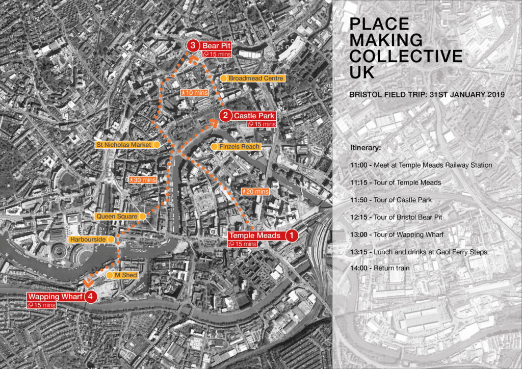
To outsiders, Bristol’s One City Plan – navigating its first year of challenges, tweaks and additions – seems to embody exactly the kind of inclusive vision this unique place needs as population, sustainability and economic pressures bear down.

The timing is right, if not too late. Savvy investors and developers are turning their attention from the Southeast, and to a degree from cities like Manchester, to “edgy”, “evolving” “property hotspot” Bristol. As CBRE put it,

as a string of high-rises prepare to take their stand over our unassuming skyline, it seems that the next chapter of our city is finally taking shape. Bristol has a new generation at its helm: changemakers who share a thirst to put this great city firmly back on the map.”  – CBRE Bristol report: https://bit.ly/2Rfl1GX

With phenomenal per-capita talent across research, design, engineering, the arts, environment, health, economics, technology and social enterprise, Bristol could capitalise on all this new investment to build the equitable, green and thriving city locals want – and visitors gush over.

Getting there is a messy proposition, though, as shown in the June closure of the contentious Bear Pit. More generally, the city’s goals could be swamped by commercial imperatives as Brexit threatens to sap the Southwest economy.

There are promising signs that the latter (at least the goal-swamping) can be avoided, mainly thanks to Bristol’s people. Labour Mayor Marvin Rees presides over both the One City Plan and a unitary government, albeit one tied into a combined authority for complex projects like the rail station. Risk-embracing entrepreneurs, artists with faithful audiences and experienced activists all thrive – although their homes and workspaces are becoming less affordable. Notably, many of the developers and agents keen to extend that “string of high-rises” also claim a personal affinity with the city and its history.

One of the most useful assets in all this is the network of urban practitioners – professional, amateur and student – who connect those groups. Whether they’re based at engineering firm hot-desks or artists’ co-ops, they seem able to speak a common language, and to listen well.

The Placemaking Collective UK got to meet about 20 of them in early 2019, hosted by Michael Cowdy of McGregor Coxall and colleagues from Mott McDonald, APG Architecture, The Circle/Bearpit Social and Wapping Wharf. Despite the cold, it was the biggest PCUK field trip yet, with lots of local people sharing perspectives and learning from each other.

The trip started at Bristol Temple Meads (aka “the Poundland of national rail stations”, touched on the St Phillips Marsh/Temple Quarter Enterprise Zone and stopped at Castle Park, the Broadmead Centre, the Bear Pit and Wapping Wharf (map below).

While every one of these places has its eye on the future, each is also locked tightly to its past – some more harmoniously than others. Historic England is naturally heavily involved in redesign of Brunel’s Grade I-listed station, but the traditional rights of taxi drivers on the unlovely forecourt may be more of a drag on design.

As Mott McDonald’s Sean Symmons put it, Temple Meads definitely doesn’t say “Welcome to Bristol!”, so the successful redevelopment of the station and surrounds are key to city ambitions.

Interesting spaces are creeping closer to the station [timeline], but the adjacent St Phillips Marsh and Enterprise Quarter – with their promised 11,000 homes and 22,000 jobs already underway – are “still dead after 6pm” and need to demonstrate that they are connected and worth investing in, despite the challenges of contaminated sites, left-over infrastructure… and being a marsh…next to a river that floods. With the national economy, regional engineering strengths and local assets firmly in Bristol’s favour, it will all come good, but it’s still a hard sell, with the inherent risk of less-than-stellar developer concessions.

With less at stake, pretty but neglected Castle Park is embracing water, with plans to reconnect or uncover buried waterways as part of a larger effort to use the city’s public realm for sustainability and recreation. Bristol’s river, canals and floating harbour are all starting to be used more interestingly, including by brewery Left-Handed Giant – which raised £1.05m on a £450,000 crowd-funding target to set up.

What few tourists get to see is the functional commercial core of the city at the Broadmead Bristol Shopping Quarter, which could be Croydon, Crawley or any dated-but-useful shopping precinct. There are some decent buildings, but the key here will be to extend the good pedestrian links from the river via Castle Park and beneath Debenham’s (as of this writing) to the soon-to-be-reworked Bear Pit.

During the Placemaking visit, Bearpit Social Café owner Miriam Delogu talked about the community efforts she and friend Simon Green and others had tried to host in the space, a submerged roundabout that’s been a refuge for rough sleepers, but one plagued with violent crime and drug abuse. She and her colleagues gave up for safety reasons, and she talked about the difficulty of trying to connect with people who just want to be left alone.

With a current population of about 450,000 and another 120,000 expected over the next 10 years, the question of who lives in Bristol, how their needs are prioritised and how they get along will be increasingly fraught.

The last stop on the trip, Wapping Wharf and Gaol Steps, could be seen as typical hipster gentrification – or as a step in the right direction. The mixed-use development will provide 38% technically affordable homes mixed in with market sale property, shops, restaurants, shared workspace and access to the water on both sides. It’s an attractive place, and clearly adds to the city’s offer. Is it an exemplar for the new One City Plan? It will be interesting to hear what plan leaders say.

Thanks to Michael Cowdy for organising and hosting, to him and fellow hosts Sean Symmons, Miriam Delogu, Adam Parsons (APG Architecture) and Louis Lane for their time and insight, and to Michael, Maria, and Paul for the additional photos.